

. . .one of the seven places in the world protected by magical stones. . .
Krakow contains the royal castle of the Polish kings, dozens of churches and cathedrals, and a great many palaces and houses dating from the Renaissance. Romanesque, Gothic and baroque edifices stand side by side in a city considered the artistic capital of Poland.
Two research projects of mine include a study at the Wieliczka Salt Mine, located near Krakow Poland as well as an investigation of the soiling inside the Wawel Castle and several museums located in the historic central district of the city. See map.
See my work: Air Pollutant Intrusion into the Wieliczka Salt Mine
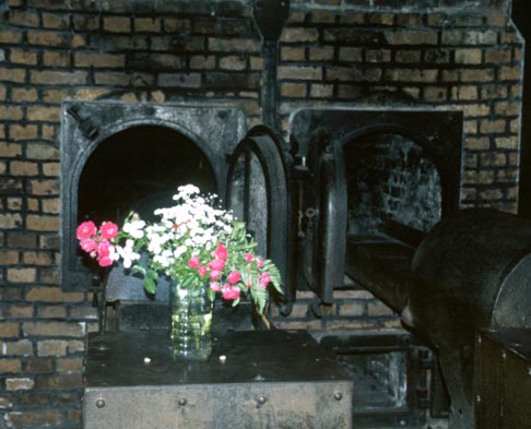
German Nazi Concentration and Extermination Camp (1940-1945)

Founded in 1921, Bialowieski is the oldest national park in Poland and one of the oldest in Europe. One third of the WH property is located in Poland, with the remainder in Belarus. On the watershed of the Baltic and Black seas, this immense forest range consisting of evergreens and broad-leaved trees is the home of some rare and interesting animals. Mammals include the European bison which was reintroduced to the park in 1929. Bird species include the black stork (Cioconia nigra), Pomeranian eagle (Aquila pomarina), tawny owl (Strix aluco), crane and raven.
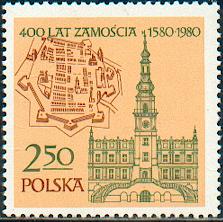
Zamosc was founded in the 16th century by the chancellor Jan Zamoysky on the trade route linking western and northern Europe with the Black Sea. The soldid fortress was able to resist attacks by both the Cossacks and the Swedes.
Torun owes its origins to the Teutonic Order, which built a castle there in the mid-13th century as a base for the conquest and evangelization of Prussia. One of its most famous people was Nicolaus Copernicus.
Mannerist architectural landscape complex and pilgrimage park.
Built in the mid 17th century, these are the largest timber-framed religious buildings in Europe.
These wooden medieval churches include:
Landscaped park along the Neisse river on the border between Poland and Germany, it was created by Prince Hermann von Puckler-Muskau from 1815 to 1844.
Joint listing with Ukraine comprised of 16 churches, built of horizontal wooden logs between the 16th and 19th centuries by communities of the Eastern Orthodox and Greek Catholic faiths.
For more links see Joint listing with Slovakia.
Joint listing with Albania, Austria, Belgium, Bosnia and Herzegovina, Bulgaria, Croatia, Czechia, France, Germany, Italy, Macedonia, Poland, Romania, Slovakia, Slovenia, Spain, Switzerland, and Ukraine. These are the largest remaining virgin forests of the European beech (Fagus sylvatica). They also hold the largest and tallest beech specimens in the world. This site originally consisted of ten separate components along an 185 km axis from the Rakhiv Mountains and the Chornohirskyi Range in the Ukraine, west along the Polonynian Ridge, to the Bukovske Vrchy and Vihorlat Mountains in Slovakia. The listing was extended in 2011 to include 5 Ancient Beech forests in Germany, further extended in 2017 to include more forests in 10 countries, and further extended in 2021.
Back to the World Heritage List
Lynn Salmon <>{
Last updated: October 18, 2022